Introduction
This essay follows the conflict chronologically from the late Ottoman period to modernity, focusing on sequence, causality, and documented political choices. Relevant modern arguments are addressed where they arise in the timeline.
Late Ottoman Phase (late 1800s–1917): Administration, Migration, and Land Change
Before World War I, Palestine was an Ottoman administrative region, not an independent sovereign Palestinian nation-state 1 2 3. This matters because the modern nation-state model—fixed borders, centralised sovereignty, and mass citizenship—is historically recent, emerging first in Europe and spreading widely in the nineteenth and twentieth centuries 4 5. In the late Ottoman world, politics was organised mainly through imperial administration, local notables, and communal structures rather than modern national citizenship.
Within that setting, Jewish immigration increased in the late Ottoman decades 6 7. Much of the land transfer to Jewish buyers and Zionist institutions occurred through legal purchase under Ottoman law 8. However, legal title transfers could still generate local grievances, because urban or absentee titleholders could sell land in ways that displaced Arab tenant cultivators and reduced their access in practice.
Reactions during this early migration wave were mixed, but hostility grew as immigration expanded and Zionist institutions developed. The argument here is about perceived power, not only headcount:
- When Jews were a small, politically subordinate minority, many local Arabs had little reason to see them as a direct challenge to Arab political or institutional dominance. In much of the pre-modern period, Jews in Muslim-ruled lands were often legally subordinate (dhimmi status), and were generally not treated as equal citizens 9 10. That hierarchy did evolve over time (including late Ottoman reforms), so this should be treated as a broad structural tendency, not a uniform rule in every place and year.
- As Jewish immigration from Europe increased, some Arab elites and movements increasingly framed the newcomers as a challenge to the existing majority order 11 12. On this view, the perceived threat was not just numbers but the combination of stronger links to external finance, denser institution-building capacity (for example, labour, settlement, and political-representative organisations), and newer land-development/agricultural methods associated with more industrialised societies 11 13 14 8. That mix could make Jewish community-building look like a future sovereign competitor rather than a static minority community 12 15.
Over the coming decades, these tensions hardened into repeated waves of Arab-on-Jewish communal violence during the early Mandate years (notably 1920–21 and 1929) 7 16. This violence provides context for how some Arab communities interpreted earlier Ottoman-era migration and land changes.
World War I and Imperial Collapse (1914–1918): From Ottoman Rule to British Occupation
World War I ended the Ottoman imperial framework that had governed the region for centuries. The Ottoman Empire entered the war in 1914 on the side of the Central Powers and was defeated by 1918 1. During the war, British forces advanced through the Levant and took control of Palestine in 1917–18, replacing Ottoman administration with British military rule on the ground 1.
The postwar settlement then converted into a new legal-administrative framework. Ottoman imperial control did not transfer to any local successor state in Palestine; instead, the victorious powers moved toward a mandate system under the League of Nations, treating the territory as administered under international trusteeship pending future self-government 17. In that setting, local political claims were argued through petitions, diplomacy, and (increasingly) violence, while Britain carried ultimate governing authority.
This is the structural break between the late Ottoman and Mandate periods: sovereignty shifted from an old empire to a modern colonial-administrative regime, and the conflict moved from being mostly about migration and land change under Ottoman law to also being about which national project the post-Ottoman order would recognise and institutionalise.
Early Mandate Phase (1917–1922): Balfour, British Rule, and Early Friction
From the outset British policy tried to hold together two commitments that were in tension: support for a “national home for the Jewish people” (Balfour, 1917) and protection of the civil and religious rights of the existing non-Jewish population 18 17.
A useful way to see the early Mandate years is as a fast transition from imperial rule to competing national projects, with Britain as both sovereign administrator and reluctant referee. In practice, the early Mandate years quickly became a struggle over three linked questions: immigration (numbers and political meaning), land and labour markets (purchase, displacement, and wages), and sovereignty (whether the “national home” language of Balfour implied eventual statehood). Arab leaders generally opposed the Balfour commitment and pressed Britain to limit immigration and move toward Arab majority self-rule; Zionist leaders pressed for immigration and institution-building as steps toward self-determination.
Transjordan (1921–1922): Three-Quarters Forgotten
Another foundational move came in 1921–22: Britain set up Transjordan as a distinct administration east of the Jordan River under Abdullah and, via the Mandate’s Article 25 arrangements, excluded it from the Jewish National Home provisions 19 20. The Mandate for Palestine was drafted to cover territory on both banks of the Jordan, but Transjordan was quickly administered separately (from 1921) and the mandate arrangements entered into force in 1923 17 21. By area, this eastern zone constituted over three-quarters of the original Mandate territory 17 19. It did not become a Palestinian sovereign state; it consolidated as a separate Hashemite polity.
In colonial-historical terms, what became Jordan was a product of imperial state-making: Ottoman administration gave way to British boundary design and Hashemite installation. There is a structural similarity with Israel here: both emerged from post-imperial transition in the Mandate era under external great-power administrative frameworks.
This matters because later pre-Israel partition proposals (Peel in 1937 and the UN proposal in 1947) addressed only the remaining territory west of the Jordan River 12 22.
Consider how contemporary international pressure, NGO focus, protest energy, and diplomatic rhetoric are overwhelmingly concentrated on Jewish sovereignty west of the Jordan River, rather than on Jordanian sovereignty over the far larger eastern share that was once inside the same Mandate outline. That asymmetry does not, by itself, prove a single cause, but it weakens the claim that the conflict is adequately explained by objection to partitions or borders alone.
A further point strengthens this inference: Jordan is not a case of frictionless Palestinian acceptance of Hashemite rule, nor a space where Palestinian nationalist energies were absent. There were direct, violent challenges to the Hashemite state by Palestinian fedayeen organisations operating in Jordan, culminating in the 1970–71 confrontation commonly known as Black September, followed by retaliation attacks including the assassination of Jordan’s Prime Minister in 1971. Earlier, King Abdullah I was assassinated in Jerusalem in 1951 by a Palestinian nationalist opposing Jordanian policy on the West Bank at the time 19 23.
Yet in modern discourse, these episodes—and the existence of Hashemite-ruled Jordanian sovereignty over most of the original Mandate territory—do not generate anything like the sustained campaigns directed at the legitimacy of Jewish sovereignty. Jordan is broadly treated as a settled fact of statehood even though it is a post-imperial Mandate product, even though it once controlled the West Bank, and even though Palestinian nationalist factions have at times treated the Hashemite state as an adversary.
If territorial partition and anti-colonial opposition to Mandate boundary-making were the primary drivers, one would expect comparably strong and sustained pressure directed at Jordan’s sovereignty over the larger eastern share, and at Jordan’s historical role on the West Bank. In practice, pressure remains concentrated on the west-of-river area in which a Jewish sovereign identity exists.
Based on this evidence, it is plausible that alongside genuine disputes over land, a rejection of Jewish ethnic and religious collective action has often operated as an equal or stronger variable for key actors in the conflict. Views have never been uniform across all Arab actors or periods, but the persistent asymmetry is a datum that any adequate explanation must account for.
Mid-Mandate Phase (1922–1936): Rising Communal Conflict
In the 1920s and early 1930s the conflict was expressed primarily as communal violence under British rule, not state-on-state war. Early outbreaks included Arab riots and attacks on Jewish communities in 1920–21 (Nabi Musa/Jerusalem and Jaffa) and again in 1929, including killings in places such as Hebron and Safed 7 16.
British authorities were both referee and ruling power, but they failed to establish durable security. At different moments they used commissions, policing, emergency controls, and repression, yet oscillated between conciliation and force without resolving core grievances.
For many Jews in the Yishuv (the pre-state Jewish community in Mandatory Palestine), these Arab-initiated attacks and British security failures made the case for organised self-defence feel immediate and non-optional.
Several Jewish underground/paramilitary organisations then emerged and split over strategy as the Mandate years progressed:
- Haganah (formed 1920): the main Jewish defence organisation during the Mandate years, broadly aligned with mainstream Zionist leadership, focused on protecting Jewish communities and building disciplined defence capacity 24.
- Irgun (Etzel) (formed 1931): a breakaway from Haganah that argued restraint was inadequate and advocated more forceful retaliation and offensive operations; over time it also fought British authority 25.
- Lehi (Stern Group) (formed 1940): a splinter from Irgun that took a more radical anti-British position during World War II and pursued violent underground tactics; this radicalisation was shaped in part by the 1939 British White Paper, which sharply restricted Jewish immigration and land purchase as European Jews entered the Holocaust years 26 27.
As the 1930s progressed, violence became increasingly reciprocal. Jewish reprisals (especially from 1937 onward through Irgun operations framed as retaliation) included attacks on Arab civilians and cannot be treated as purely reactive self-defence; some episodes were excessive, morally questionable, or strategically counterproductive. At the same time, earlier anti-Jewish violence and repeated British inability to reliably protect Jewish civilians help explain why many in the Yishuv concluded organised self-defence—and sometimes escalation—were necessary.
These organisations did not emerge in a vacuum: they grew out of a cycle of violence, British security failure, and strategic disagreement inside the Yishuv over how to respond. The harder question is not whether defence was legitimate, but where defence ended and retaliatory civilian targeting began. This security trajectory also unfolded alongside repeated Arab leadership rejection of pre-1948 partition diplomacy, especially Peel in 1937, reinforcing the belief among many Jews that political compromise alone would not secure their safety.
Late Mandate Phase (1936–1947): Revolt, Partition, and Wartime Radicalisation
In 1936, Palestinian Arab leaders and factions launched a general strike that expanded into the 1936–39 Arab Revolt, with attacks on Jewish communities, British forces, and infrastructure 11. Britain responded with heavy counterinsurgency force. By 1939, much of the Palestinian Arab leadership and armed network had been weakened, fragmented, jailed, or pushed into exile, which later affected Arab war coordination in 1947–49 11.
Against this backdrop of violence, Britain concluded that the Mandate was becoming ungovernable, and in 1937 backed the Peel Commission’s partition concept 12. Peel proposed three zones: a Jewish state, an Arab state linked to Transjordan, and a British-controlled corridor centred on Jerusalem 12.
Table 1: Peel Commission partition proposal (1937), west of the Jordan
Source: 12
| 1937 Peel partition proposal (west of the Jordan) | Land share (%) | Population share (%) | Jews (absolute) | Arabs (absolute) | Total (absolute) |
|---|---|---|---|---|---|
| Jewish state | ~17% | ~53% Jewish / ~47% Arab | ~258,000 | ~225,000 | ~483,000 |
| Arab state (linked to Transjordan) | ~75% | Over 99% Arab | ~1,250 | ~690,000 | ~691,250 |
| British-controlled zone (Jerusalem corridor + retained urban districts for a period) | ~8% | ~60% Jewish / ~40% Arab | ~125,000 | ~85,000 | ~210,000 |
The response to Peel is the key analytical point: Jewish leadership accepted the plan in principle, while Arab leadership rejected it 12 15. That rejection is difficult to explain on three grounds:
- Land: the Arab side was being offered the vast majority of the west-of-Jordan area (about 75 - 80%).
- Population: the proposed Jewish state was still close to parity (about 53% Jewish and 47% Arab before transfer), while the proposed Arab state remained overwhelmingly Arab.
- Immediate threat at that stage: this was pre-1948, before the later wartime mass Palestinian displacement and before any Israeli state existed; Jewish population growth had mainly occurred through immigration under Ottoman/British legal frameworks and land purchase. The main communal violence waves up to that period were Arab riots and revolt against Jewish communities, with some Jewish retaliatory attacks by the late 1930s.
Because land share, population balance, and pre-1948 threat conditions appear insufficient for the rejection of Peel based on the above analysis, a clearer potential explanation emerges: the core objection for the Arabs was the principle of any Jewish sovereignty at all.
Peel was one of the most expansive Arab-state opportunities formally offered west of the Jordan, and its rejection set a pattern that reappeared in 1947 and continued for decades.
This is striking because a common modern diplomatic refrain is that a two-state solution could be formed on or near the 1967 lines (often with swaps) 28 29. But if you zoom out to the full post-Ottoman Mandate, Jordan was carved out as roughly three-quarters of that territory. If you then combine that with a Peel-style Arab state taking most of the remaining west-of-the-Jordan land, a Palestinian Arab state could have covered about ~94% of the original Mandate area: 0.75 (Transjordan) + (0.75 × 0.25) (Peel Arab-state share of what was left) = 0.9375. That is, Arabs could plausibly have ended up with essentially the whole space, if the Hashemites had formed a Palestinian state and Arab leadership had accepted Peel 17 19 12.
Consider the inverse as well: under Peel, the proposed Jewish state was only about ~17% of west-of-Jordan, which is roughly ~4–5% of the original Mandate. Yet Jewish leadership accepted that framework even though the proposed Jewish state would have been only ~53% Jewish (near parity). Against that baseline, it is difficult to frame the Jewish side as uniquely “unfair” or “unreasonable” in this period 12 15 17 19.
Modern infographics often misrepresent this period and omit key diplomatic context (especially the earlier Peel proposal and the Transjordan carve-out). The figures are analysed in detail later in the Analysis section.
1938–1947
The decade after Peel made compromise harder, not easier. Britain stepped back from Peel in 1938 because implementation looked unworkable: populations were deeply mixed, transfer proposals were politically and morally explosive, and partition was judged difficult to enforce under continuing unrest 15 12. In 1939 Britain then issued the White Paper, which reset Mandate policy by capping Jewish immigration at 75,000 over five years, restricting Jewish land purchase across large areas, and proposing an independent Palestine within ten years with any further Jewish immigration dependent on Arab consent 27. Those restrictions came just as European Jews were entering the Holocaust years, intensifying Jewish urgency around refuge and sovereignty.
During the war, Hajj Amin al-Husayni (the Grand Mufti of Jerusalem) was one of the most influential Palestinian Arab leaders. His role was not just religious: through the Mufti’s office and the Supreme Muslim Council, he had influence over Islamic courts, waqf funds (religious charitable trusts), clerical appointments, and public messaging. In wartime he aligned with Nazi Germany, met Hitler in 1941, and promoted anti-Jewish propaganda. That mattered to the conflict because rhetoric from a leader with this reach could harden mass attitudes, strengthen rejectionist mobilisation, and support the argument that this was a struggle over Jewish legitimacy itself, not only over borders 30 31 32 33 34.
After 1945, the conflict increasingly became a three-sided struggle among Britain, the Yishuv, and Palestinian Arab forces, with Jewish underground organisations escalating anti-British operations while immigration battles and communal mistrust deepened. By 1947 Britain referred the question to the UN, which moved through UNSCOP to Resolution 181 35 22.
UN Partition and War (1947–1949): Civil War and Interstate Invasion
By 1947, the territorial question had already been narrowed to the land west of the Jordan River, because Transjordan had already been separated from most of the original Mandate territory. The UN then proposed Resolution 181 as a second partition model. Compared with Peel, the land split moved sharply toward a much larger proposed Jewish state.
Table 2: UNGA Resolution 181 partition proposal (1947), west of the Jordan
| 1947 UNGA Resolution 181 partition proposal (west of the Jordan) | Land share (%) | Population share (%) | Jews (absolute) | Arabs and others (absolute) | Total (absolute) |
|---|---|---|---|---|---|
| Jewish state | ~56% | ~55% Jewish / ~45% Arab-and-other | ~498,000 | ~407,000 | ~905,000 |
| Arab state | ~43% | ~1% Jewish / ~99% Arab-and-other | ~10,000 | ~725,000 | ~735,000 |
| Jerusalem (international administration) | ~1% | ~49% Jewish / ~51% Arab-and-other | ~100,000 | ~105,000 | ~205,000 |
Resolution 181 proposed two states, included civil and minority-rights guarantees in both, and set Jerusalem under a separate international regime 22. Like Peel, it embedded substantial minorities (Table 2), while the proposed Arab state remained overwhelmingly Arab. Arab leadership had already rejected the more Arab-favourable Peel proposal in 1937, and in 1947 it rejected partition again, while Jewish leadership accepted partition in principle in both rounds 7 15.
This supports the same inference as in the Peel section: land percentages alone do not explain the 1947 rejection when a more favourable land offer had already been rejected and the proposed Arab state still retained near-total demographic dominance. In 1947, the practical alternative to acceptance was war.
The sequence of events went as follows:
- November 1947: the UN passed Resolution 181; Jewish leadership accepted in principle, Arab leadership rejected 22 7.
- Late 1947 to May 1948 (civil-war phase): Arab armed groups and local militias launched attacks on Jewish roads, neighbourhoods, and communities inside the Mandate; fighting then expanded across mixed cities and key supply routes 36 7.
2.1. April 1948 (within that civil-war phase): Deir Yassin. Irgun and Lehi attacked the village during fighting around the Jerusalem corridor, presenting the operation as part of securing access roads to besieged Jewish areas of Jerusalem and removing hostile positions near that route. It is included explicitly because it remains one of the most cited episodes in both historical memory and modern debate, and excluding it would make the chronology look selective. Deir Yassin is widely cited because of the civilian deaths (commonly cited around 100), its shock effect in wartime propaganda and public memory, and its role in intensifying fear and flight dynamics. Retaliatory atrocities followed, including the Hadassah convoy attack (about 80 killed) 37 7. - May 1948 onward (interstate phase): after Israel declared independence, Egypt, Transjordan, Syria, Iraq, and Lebanon invaded from multiple fronts (south, east, north-east, and north), widening the conflict into a regional war 36.
This chronology supports the argument that the Jewish side did not initiate the war sequence: the first stage was Arab rejection and attacks in the civil-war period, followed by Arab state invasion after independence.
During the war, the Nakba unfolded, with roughly 700,000 - 750,000 Palestinians displaced 38.
In the years after 1948, a lesser known second regional refugee crisis unfolded as Jewish communities were pushed out from many Arab states through intimidation, legal discrimination, denaturalisation, property seizure, and expulsion pressures. Roughly 850,000 Jews were displaced (with some estimates higher), including major departures from Iraq and Yemen, expulsions and forced departures from Egypt and Libya, and sustained outflows from Syria, Lebanon, Morocco, Tunisia, and Algeria 39.
This second refugee crisis supports the argument that the conflict was not only about one set of borders, but also about identity and the regional status of Jews. In many Arab states after 1948, authorities and the public treated local Jewish communities as tied to the Palestinian-Israeli conflict regardless of individual political views. In practice, the distinction often made today between anti-Zionism and antisemitism was minimal in state practice or culture, with little distinction made between Jews as citizens and Zionists as political actors (or Israel itself). The result was widespread anti-Jewish pressure—riots, discriminatory laws, denaturalisation, property seizure, and expulsions or forced departures across multiple countries.
This pattern suggests the conflict was not only a dispute over borders in Palestine, but also reflected broader rejection of Jewish collective legitimacy in significant parts of the region.
Analysis (Pre-1949)
No internationally recognised sovereign Palestinian state existed before 1948. Under the Ottomans, Palestine functioned as an imperial administrative region, and under Britain it became a Mandate territory governed through imperial trusteeship rather than local sovereign statehood 1 2 17.
State formation after imperial rule happened in two different ways on the former Mandate map:
- East of the Jordan: Britain separated Transjordan and this became the Hashemite Kingdom of Jordan in 1946, but not as a Palestinian sovereign state 19 17.
- West of the Jordan: after the collapse of Ottoman and then British imperial control, Israel’s declaration in 1948 created the first modern sovereign state in the west-of-river territory that had been Mandatory Palestine 17.
On migration and property, Jewish immigration and land acquisition before 1948 largely occurred through legal entry channels and legal purchase under Ottoman and British law (especially before the late-Mandate restrictions); even so, these transactions often produced real tenant-displacement grievances on the Arab side 8 27 7.
On conflict causality, the pattern is consistent. Major communal violence waves in the Mandate years were initiated primarily by Arab riots/revolt (1920–21, 1929, 1936–39), while Britain failed to resolve the contradiction built into Mandate policy. Jewish violence against Arab civilians did occur from 1937 onward through Irgun operations; many were framed as retaliation, but not all can be treated as purely reactive self-defence. In diplomacy, Arab leadership rejected both Peel (1937) and UN partition (1947) while Jewish leadership accepted partition in principle in both rounds. In war chronology, rejection was followed first by Arab militia attacks in the civil-war phase and then by interstate invasion in 1948 by Egypt, Transjordan, Syria, Iraq, and Lebanon 16 11 12 22 36.
The human result by the end of the period was two refugee crises: roughly 700,000–750,000 Palestinians displaced in the Nakba and roughly 850,000 Jews displaced from Arab countries, often without any attempt to distinguish Zionist or Israeli from “Jewish” 38 39.
Map analysis
Modern attempts to show maps of this conflict during this period often misrepresent the history, ignore attempts at partition and Arab rejections, and distort land and population distributions. Two recurring problems appear in both examples below: they frame the story as if it occurs only west of the Jordan River, and they do not explain the earlier separation of Transjordan and the formation of Jordan, even though that was most of the original Mandate territory 17 20 21 19.
Figure 1: Israel’s gradual dispossession of Palestinians from 1946 - Present 40
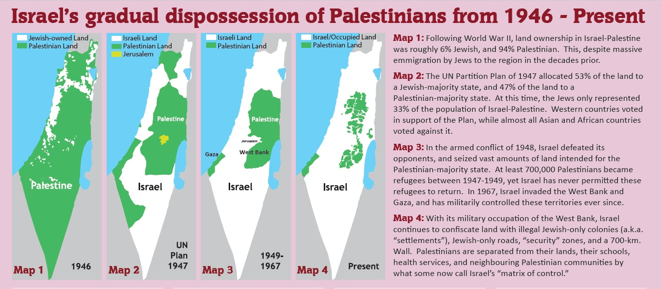
Figure 1 is rhetorically effective but misleading: it blends true-sounding numbers with category errors and then uses that confusion to imply a moral and legal conclusion. That framing matters because it encourages the reader to treat “who owns land” as interchangeable with “who should have sovereignty.”
Figure 1 contains four internal panels with text. Quoting the key text, then addressing each claim:
Map 1 text (1946)
Following World War II, land ownership in Israel-Palestine was roughly 6% Jewish, and 94% Palestinian. This, despite massive emmigration [sic] by Jews to the region in the decades prior.
The first misrepresentation here is the starting date. Fast-forwarding to “following World War II” skips the most important diplomatic fact for this topic: Britain had already proposed partition in 1937 (Peel) and Arab leadership rejected it even though it offered Arabs the vast majority of west-of-Jordan territory (see Table 1) 12 15.
The second misrepresentation is definitional. The oft-cited “94% Palestinian-owned” figure is a category error: it is a residual (100% minus a Jewish holdings figure), not a measured private Palestinian ownership statistic. Mandate-era land ownership tables do exist, and they do not support anything like 94% Palestinian private ownership of total land. In Hadawi’s 1945 classification (position as at 1 April 1945), Arab individual/partnership ownership is about 48.50% of total land, Jewish ownership about 5.67%, public lands about 5.67%, and about 40.16% is uncultivable/unassigned land in the Beersheba sub-district (ownership undefined). So “Jews owned ~6%” does not logically imply “Palestinians owned ~94%”; it implies “Jews owned a small share of the total land area,” with the remainder being a mix of other ownership categories and undefined/uncultivable classifications 41.
This also obscures the pre-1948 mechanism of land acquisition: the pre-1948 Jewish land base was primarily built through legal purchase under Ottoman and then British legal frameworks. Finally, it gestures at “massive emigration” while ignoring the biggest late-Mandate fact about immigration policy: Britain sharply restricted it in 1939 via the White Paper, precisely as European Jews were entering the Holocaust years 8 27.
Map 2 text (1947)
The UN Partition Plan of 1947 allocated 53% of the land to a Jewish-majority state, and 47% of the land to a Palestinian-majority state. At this time, the Jews only represented 33% of the population of Israel-Palestine. Western countries voted in support of the Plan, while almost all Asian and African countries voted against it.
This panel collapses categories again: the UN plan drew state borders over a patchwork of private, communal, and public land; it was not an “allocation” of privately owned land from one group to another. And the plan was explicitly designed to create two states with minorities inside each: the proposed Jewish state still included a very large Arab population (~45% in the proposal), while the proposed Arab state remained overwhelmingly Arab (~99%). Arab leadership rejected this proposal, and it had also rejected the earlier, more Arab-favourable Peel proposal 22 35 15.
Map 3 text (1948 and 1967)
In the armed conflict of 1948, Israel defeated its opponents, and seized vast amounts of land intended for the Palestinian-majority state. At least 700,000 Palestinians became refugees between 1947-1949, yet Israel has never permitted these refugees to return. In 1967, Israel invaded the West Bank and Gaza, and has militarily controlled these territories ever since.
The language “seized vast amounts of land intended for…” compresses cause and effect into a single moral sentence and treats the UN plan as if it had been implemented. The core sequence is: the UN passed 181; Jewish leadership accepted in principle; Arab leadership rejected; the Arabs initiated a civil war; and neighbouring Arab states invaded Israel after its declaration of independence. Once war replaces diplomacy, the proposed lines become moot and the lines that matter are the armistice lines that end the fighting. On refugees, the Palestinian displacement is real and central, but the graphic becomes selectively moral by isolating only one refugee flow and ignoring the second regional refugee crisis after 1948 (roughly ~850,000 Jews displaced from Arab countries) 22 7 36 39.
Map 4 text (present)
With its military occupation of the West Bank, Israel continues to confiscate land with illegal Jewish-only colonies (a.k.a. “settlements”), Jewish-only roads, “security” zones, and a 700-km. Wall. Palestinians are separated from their lands, their schools, health services, and neighbouring Palestinian communities by what some now call Israel’s “matrix of control.”
Whatever one thinks of post-1967 policy (addressed later), it is not evidence for the 1946 and 1947 claims this graphic implies. The rhetorical move is to start with a confusing ownership claim in 1946, jump to a simplified partition story in 1947, and then end at “Present” so the reader emotionally backfills the earlier claims with later images of occupation.
Figure 2: Evolution of Israel/Palestine borders 42
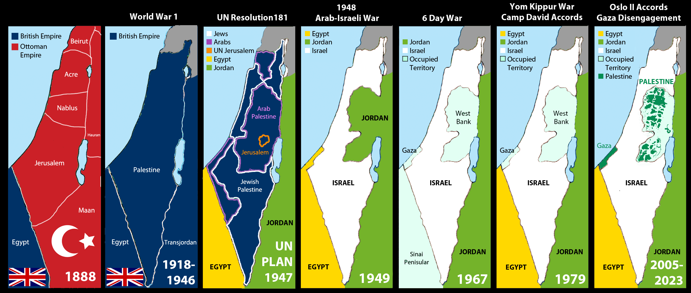
Figure 2 looks like a neutral timeline, but it mixes administrative districts, proposals, and wartime outcomes as if they are all the same kind of “border.”
Panel 1 (1888): In a slightly more honest representation, the figure does not label the area “Palestine” as any Ottoman administrative unit. This is correct: under the Ottomans “Palestine/Filastin” was commonly a geographic or regional descriptor, not a standard province name; the area that later became Mandatory Palestine was administered through Ottoman provinces and districts (including the Mutasarrifate of Jerusalem and surrounding sanjaqs under larger Syrian provinces) 2 3.
Panel 2 (1918–1946, labeled “World War 1” [sic]): the World War I label is factually incorrect. World War I ended in 1918, so “1918 - 1946” cannot be a World War I map; it is the post-war occupation/administration period and then the Mandate era up to Jordanian independence. This panel also drops “Transjordan” into the map without any explanation as to when this was established or why. The Mandate for Palestine was designed to include territory on both banks of the Jordan River, but Transjordan was quickly set up as a separate administration covering roughly three-quarters of the land east of the river in 1921 1 17 20 21 19.
Panel 3 (UN Resolution 181, 1947): if the graphic is going to show the UN proposal in detail, it should also show the Peel proposal somewhere. Peel offered an Arab state of about 75 - 80% within this area and a Jewish state of about 17 - 20% (see Table 1), and it was explicitly rejected by Arab leadership. That earlier, more Arab-favourable proposal is omitted here. The UN partition lines are also presented in the same visual mode as later “real” borders, but it was a proposal, not a border that was implemented, and it is not explained as a proposal. This invites viewers to mistakenly treat the depicted lines as if they were put into place 12 15 22 36.
Panel 4 (1948 Arab-Israeli War): the panel describes the war but does not mention how the interstate phase began. After Israel declared independence, five Arab states invaded from multiple fronts: Egypt, Transjordan, Syria, Iraq, and Lebanon. Omitting that turns a specific sequence of decisions and actions into a vague inevitability 36.
Bibliography
Footnotes
-
Encyclopaedia Britannica. “Palestine.” https://www.britannica.com/place/Palestine ↩ ↩2 ↩3 ↩4 ↩5
-
PalQuest. “Ottoman Territorial Reorganization, 1840-1917.” https://www.palquest.org/en/highlight/155/ottoman-territorial-reorganization-1840-1917 ↩ ↩2 ↩3
-
Salim Tamari (Institute for Palestine Studies). “Shifting Ottoman Conceptions of Palestine: Part 2: Ethnography and Cartography.” https://www.palestine-studies.org/en/node/78453 ↩ ↩2
-
Encyclopaedia Britannica. “Nation-state.” https://www.britannica.com/topic/nation-state ↩
-
Encyclopaedia Britannica. “Peace of Westphalia.” https://www.britannica.com/event/Peace-of-Westphalia ↩
-
Encyclopaedia Britannica. “Zionism.” https://www.britannica.com/topic/Zionism ↩
-
Encyclopaedia Britannica. “Israeli-Palestinian conflict.” https://www.britannica.com/topic/Israeli-Palestinian-conflict ↩ ↩2 ↩3 ↩4 ↩5 ↩6 ↩7 ↩8 ↩9
-
Encyclopaedia Britannica. “Jewish National Fund.” https://www.britannica.com/topic/Jewish-National-Fund ↩ ↩2 ↩3 ↩4
-
Encyclopaedia Britannica. “Dhimmah.” https://www.britannica.com/topic/dhimmah ↩
-
Encyclopaedia Britannica. “Jizya (jizyah).” https://www.britannica.com/topic/jizya ↩
-
Encyclopaedia Britannica. “Arab Revolt (1936-1939).” https://www.britannica.com/event/Arab-Revolt-1936-1939 ↩ ↩2 ↩3 ↩4 ↩5
-
Palestine Royal Commission (Peel Commission). Report (July 1937), via UNISPAL. https://www.un.org/unispal/document/auto-insert-196499/ ↩ ↩2 ↩3 ↩4 ↩5 ↩6 ↩7 ↩8 ↩9 ↩10 ↩11 ↩12 ↩13
-
Encyclopaedia Britannica. “Jewish Agency.” https://www.britannica.com/topic/Jewish-Agency ↩
-
Encyclopaedia Britannica. “Histadrut.” https://www.britannica.com/topic/Histadrut ↩
-
Encyclopaedia Britannica. “Peel Commission.” https://www.britannica.com/topic/Peel-Commission ↩ ↩2 ↩3 ↩4 ↩5 ↩6 ↩7 ↩8
-
Encyclopaedia Britannica. “Arab riots of 1929.” https://www.britannica.com/event/Arab-riots-of-1929 ↩ ↩2 ↩3
-
Yale Law School Avalon Project. “The Palestine Mandate (1922).” https://avalon.law.yale.edu/20th_century/palmanda.asp ↩ ↩2 ↩3 ↩4 ↩5 ↩6 ↩7 ↩8 ↩9 ↩10 ↩11
-
Yale Law School Avalon Project. “The Balfour Declaration (1917).” https://avalon.law.yale.edu/20th_century/balfour.asp ↩
-
Encyclopaedia Britannica. “Jordan.” https://www.britannica.com/place/Jordan ↩ ↩2 ↩3 ↩4 ↩5 ↩6 ↩7 ↩8
-
Council of the League of Nations (via PalQuest). “Article 25 of the Palestine Mandate…” (16 September 1922). https://www.palquest.org/en/historictext/37961/council-league-nations-article-25-palestine-mandate-approving-memorandum-british-representative ↩ ↩2 ↩3
-
League of Nations Council (via UNISPAL). “Minutes of the Council of the League of Nations (entry into force of the Palestine Mandate)” (29 September 1923). https://www.un.org/unispal/document/auto-insert-196917/ ↩ ↩2 ↩3
-
United Nations General Assembly Resolution 181 (II). https://www.un.org/unispal/document/auto-insert-185393/ ↩ ↩2 ↩3 ↩4 ↩5 ↩6 ↩7 ↩8 ↩9
-
Encyclopaedia Britannica. “West Bank.” https://www.britannica.com/place/West-Bank ↩
-
Encyclopaedia Britannica. “Haganah.” https://www.britannica.com/topic/Haganah ↩
-
Encyclopaedia Britannica. “Irgun Zvai Leumi.” https://www.britannica.com/topic/Irgun-Zvai-Leumi ↩
-
Encyclopaedia Britannica. “Stern Gang (Lehi).” https://www.britannica.com/topic/Stern-Gang ↩
-
Yale Law School Avalon Project. “British White Paper of 1939.” https://avalon.law.yale.edu/20th_century/brwh1939.asp ↩ ↩2 ↩3 ↩4
-
UN Security Council Resolution 242 (1967). https://undocs.org/S/RES/242(1967) ↩
-
Obama White House Archives. “Remarks by the President on the Middle East and North Africa” (2011-05-19). https://obamawhitehouse.archives.gov/the-press-office/2011/05/19/remarks-president-middle-east-and-north-africa ↩
-
United States Holocaust Memorial Museum (Holocaust Encyclopedia). “Hajj Amin al-Husayni: The Mufti of Jerusalem.” https://encyclopedia.ushmm.org/content/en/article/hajj-amin-al-husayni-the-mufti-of-jerusalem ↩
-
United States Holocaust Memorial Museum (Holocaust Encyclopedia). “Hajj Amin al-Husayni meets Hitler.” https://encyclopedia.ushmm.org/content/en/film/hajj-amin-al-husayni-meets-hitler ↩
-
United States Holocaust Memorial Museum (Holocaust Encyclopedia). “Hajj Amin al-Husayni: Wartime Propagandist.” https://encyclopedia.ushmm.org/content/en/article/hajj-amin-al-husayni-wartime-propagandist ↩
-
Encyclopaedia Britannica. “Amin al-Husayni.” https://www.britannica.com/biography/Amin-al-Husayni ↩
-
Encyclopaedia Britannica. “Supreme Muslim Council.” https://www.britannica.com/topic/Supreme-Muslim-Council ↩
-
United Nations Special Committee on Palestine (UNSCOP). Report to the General Assembly (1947). https://www.un.org/unispal/document/auto-insert-179435/ ↩ ↩2 ↩3
-
Encyclopaedia Britannica. “Arab-Israeli wars.” https://www.britannica.com/event/Arab-Israeli-wars ↩ ↩2 ↩3 ↩4 ↩5 ↩6
-
Encyclopaedia Britannica. “Deir Yassin.” https://www.britannica.com/place/Deir-Yassin ↩
-
UNRWA. “Palestine Refugees.” https://www.unrwa.org/palestine-refugees ↩ ↩2
-
U.S. Congress. H.Res.185 (110th Congress). https://www.congress.gov/bill/110th-congress/house-resolution/185/text ↩ ↩2 ↩3
-
Canadians for Justice and Peace in the Middle East (CJPME). “Best Maps of Israel/Palestine.” https://www.cjpme.org/mapss ↩
-
Sami Hadawi. “Village Statistics 1945: A Classification of Land and Area Ownership in Palestine” (1970). https://sabilalhaya.wordpress.com/wp-content/uploads/2015/02/village-statistics-1945-hadawi.pdf ↩
-
Reddit (r/Maps). “[1888 - 2023] Evolution of Israel / Palestine borders from the Ottoman Empire to independence.” https://www.reddit.com/r/Maps/comments/1762iki/1888_2023_evolution_of_israel_palestine_borders/ ↩